


A great ship must have deep water. ~ Dutch Proverb
Lake Superior is the largest body of fresh water on the globe, and is the highest and most western of the five Great Lakes. It is situated not far from the center of the continent of North America. The general form of this lake is that of a wide crescent with the outer curve toward the north. Its greatest length is from east to west, about 355 miles, and its greatest breadth is about 160 miles. Its area is about 32,000 square miles. The depth is 1,000 feet, and the surface is very nearly 602 feet above the sea, hence the bottom is about 400 feet below the level of the Atlantic Ocean. The surface of this lake is about 23 feet above that of Lake Michigan and Lake Huron, the greater part of this difference being in the river St. Marys, which connects Lake Superior with Lake Huron. (http://www.maritimehistoryofthegreatlakes.ca/GreatLakes/Documents/HGL/default.asp?ID=c004)

Gros Cap, Superior Heritage Coast
Long before colonization along the shores of Lake Superior, the First Nations fished, traded and maintained a portage around the rapids of the St. Marys River. Eventually both sides of the river -today Sault Ste. Marie Michigan and Sault Ste. Marie, Ontario, became a hub and a point of junction for the Fur Trade that spanned 3,000 miles which stretched from Montreal to Sault Ste. Marie and to the North Country above Lake Superior.
A few centuries later, the St. Marys River retains the natural features ideal of a trading post and with more than one hundred years of industrialization, the north shore has been built up providing infrastructure supporting the fourth largest Port on the Great Lakes today. Anshumali Dwivedi, CEO of the Port of Algoma, takes note of the historical significance and ideal layout of the Port that was formerly owned by Essar Steel. Though still part of the Essar ‘family’, in 2014 Essar Ports Global Holdings Inc. assumed ownership of the Port of Algoma.
“These are the kinds of projects which can be very helpful for a community. Wherever globally a commercial Port has come up that city -and it doesn’t happen overnight, but over a decade or two, it kind of blossoms. And it grows into a much larger trade centre. If you look at any of the large towns of the world they all come up around trading destinations. The advantage that the Sault has is that historically it has been a trading place,” remarked Dwivedi.
The Port of Algoma project aims to redevelop the existing port facilities to accommodate a public access port that would be accessible for industrial as well as commercial usage and dockage. Four hundred and forty acres are currently available on site for warehousing, storage and enterprise development.

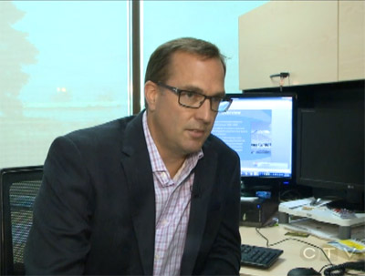
Anshumali Dwivedi, CEO, Port of Algoma
Dwivedi noted the Port is strategically located as an international marine gateway also providing direct access by rail and highway networks.
“We are geographically placed at the tip of Lake Superior connecting to Lake Huron and Lake Michigan, we are at the junction of the Trans- Canada highway 17 and U.S. I-75 and then we also have CN and CP access at the Port. Factoring all of this in, and factoring what traffic is going through and passing us by we ask ‘is there potential to bring some of that traffic by boat and take the traffic off the highways’. That is one good environmental benefit that can happen. The Port will have the potential of taking long haul truck traffic off the highways,” commented Dwivedi.
A 2013 report Regional Harbour Expansion and Business Marketing Analysis, prepared by KPMG states that, “During 2011, the harbour complex handled a total of 5.5 million tonnes of commodities, making it the fourth largest port on the Canadian Great Lakes by volume. Of this amount, 4.8 million tonnes related to Essar Steel Algoma Inc. (ESAI) shipments, with other regional industries accounting for the remaining volume. While markedly smaller than the volumes handled by ESAI for its own needs, the ability to transport products by vessels benefits a number of local companies, with Tenaris Algoma Tubes Inc. being the second largest user of the harbour complex.”
*The KPMG report is attached at the end of this article.
Phase 1 of the Port of Algoma project has included reaching out to commercial businesses in the region to inform them about the advantages of moving orders via ship delivery.
“We are trying to educate businesses about how to use a Port. If they are sending their materials by truck over a long distance we tell them that putting it on a boat means there’s going to be less diesel consumption. If businesses don’t have enough to load up a boat then it is possible for 3 or 4 businesses to charter a shipment at the same time. All of that means less diesel and that is good for the environment. It also makes good business sense. The less diesel burned the more saved,” stated Dwivedi.
In partnership with the Port of Algoma, two consulting groups, KPMG and AECOM, have been engaged through the City of Sault Ste. Marie. KPMG is conducting the business case analysis and looking at information such as traffic flow and potential cargo opportunities. AECOM is conducting a study of the environmental and engineering aspects associated with the redevelopment of the Port.
According to Dan Hollingsworth, Executive Director of Business and Development with Sault Ste. Marie’s Economic Development Corporation, phase one of the Port of Algoma project totals 5.3 million dollars with 2.12 million coming through the feds, 2.12 million coming through the province, about $800,000 from Essar Ports Global Holdings and what is left of the balance is offset by the City of Sault Ste. Marie.
*****
Information provided by the Ministry of Transportation shows that:
- On an average day, 1,200 commercial vehicles travel on Highway 17 between Sudbury and Sault Ste. Marie and 500 commercial vehicles travel on the same highway between Sault Ste. Marie and Thunder Bay
- On an average day, almost 10,500 commercial vehicles travel in Northern Ontario with a commodity valued at $232 million
- The average commercial vehicle trip length of trips using Northern Ontario roads is 544 kilometers
- Between 2006-2010 commercial vehicle activity increased by 11% in Northern Ontario
On the basis of daily trips and commodity values:
- 33% of all commercial vehicle trips involve empty vehicles
- Manufactured goods represent 6% of all trips and 15% of the cargo value
- Machinery represent 3% of all trips and 17% of the cargo value
- Food represents 8% of all trips and 9% of the cargo value
- Wood and wood products represent 10% of all trips but only 4% of the cargo value
- Automotive goods represent 2% of all trips and 12% of the cargo value
- Minerals represent 7% of all trips but only 4% of the cargo value
And how about those nasty carbon emissions (CO2)?
Based on data from Natural Resources Canada, it is estimated there were 2.6 megatonnes of carbon/GHG emissions from commercial vehicles in Northern Ontario in 2012. As a comparison, on-road freight transportation emissions were 13.6 megatonnes CO2 in Ontario in 2012.
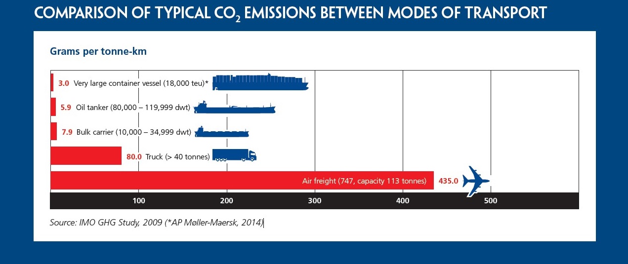
A summary entitled Shipping, World Trade and the Reduction of Co2 Emissions: United Nations Framework Convention on Climate Change, by the International Chamber of Shipping provides a comparison of typical CO2 emissions between modes of transport.
(click image to increase size)
The summary also indicates:
- International shipping industry has a commitment to improve the efficiency of new ships with a target to reduce CO2 Emissions by 50% per tonne/km by 2050.
- Since 2013 the global shipping industry has been on track to reduce its CO2 Emissions per tonne/km by more than 20% by 2020.
- Global shipping, which transports around 90% of world trade, only produced about 2.2% of the world’s total greenhouse gas emissions during 2012 compared to 2.8% in 2007. Total shipping emissions have reduced by over 10% during the same period.
*****
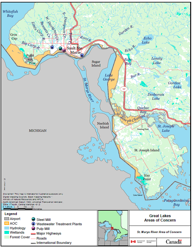
St. Mary’s River, Areas of Concern
In 1987 the St. Marys River Remedial Action Plan (RAP) was established following an amendment of the Canada-United States Great Lakes Water Quality Agreement. The agreement identified Areas of Concern (AOC) and include the site along the St. Marys River. Thirty years later, reports are showing a trend towards less contamination in three hot spot areas: east of Top Sail Island, an area near Bellevue Marine Park and an area around Lake George Channel. These areas experience higher than suggested government levels of contaminants, though these sediments are found 10 cm beneath the first layer of sediment, and do not present a tremendous risk to the environment and human health at present.
“However, with issues like water levels going down in the Great Lakes and possible increases in freighter traffic which could result from projects like the Port coming to the Sault, that’s when these areas could become of greater concern, as problem sediments could be re-exposed,” explained Corrina Barrett, St. Marys RAP Coordinator, in an interview with the Northern Hoot earlier this year.
Studies of the sediment in St. Marys River shows that one centimeter of compressed and clean sediment are overlaying historical contaminant elements each year. As well the benthic community (tiny organisms on the bottom of the river) and the fish community are returning to a level expected of the St. Marys River.
Dwivedi is aware of the concerns associated with dredging the bottom of the river explaining that the Port, is a redevelopment and not a new development that already supports sea way depth.
“The docks can already take the largest of the vessels so there is no significant dredging that we’re looking at,” remarked Dwivedi.
Dwivedi added, “Now there is one patch where we may need dredging which is around the Vidal Shoals but further study would tell us that. If there are boats coming right now they have to go very carefully and if they touch bottom then we’re going to have an accident. So we’re just trying to get the consultants together to find if that patch will need to be dredged or not. If that needs to be dredged- that is one portion where you will need a detailed environmental assessment. So they will need to go through the full permitting process for that. And that’s why we are asking the consultants to be doubly sure if we need to go after that because we want to keep life simple for us. We’re very efficient in whatever we’re doing. If I really don’t need to dredge then I would rather not.”
Dwivedi added that should the consultants advise prudence in dredging for traffic safety, he would consult the appropriate governmental agencies for direction.
Dwivedi notes that there is also need to be aware of the risk presented by the discharge of ballast water. Ballast water provides stability and maneuverability to ships as their cargo loads increase or decrease. Water is pumped in to the ship’s ballast tanks but invasive species and pollutants can also be drawn in and later released in unaffected areas.
“We would need to be sure checks and balances were in place,” commented Dwivedi.
Having relocated from India to Sault Ste. Marie about one year ago, Dwivedi has had an opportunity to explore the region. He was alarmed by what he observed as lax environmental protections for the provinces waterways and with particular regard to Northern Ontario.
“I’ve been shocked with a few things that I’ve seen on the Great Lakes. Up north I saw mercury contamination in the water- I didn’t expect that. It’s crazy the amount of environmental damage that has happened from paper mills. What’s been happening on the Great Lakes? We need to make developments much more current with the environmental norms today. What I’ve seen up North -it was a little shocking because you would expect the environmental rules to be stricter,” shared Dwivedi.
*****
As explained by Hollingsworth, AECOM is consulting with groups like the Ministry of the Environment, the Ministry of Natural Resources and Forestry and the Department of Fisheries and Oceans.
“All these groups need to be consulted before the project. Any work with respect to any changes to the footprint or how it’s going to be redeveloped have to be identified and any concerns mitigated through respective agencies. It should be clear this isn’t building on a green field site. This is a brown field redevelopment of an existing site,” commented Hollingsworth.
One might assume that with the possibility of dredging during the redevelopment process, as well as the access to public funding and the use of a federal and provincial waterway system that a federal environmental assessment would be in order.
According to Elaine McArdle, spokesperson with the Canadian Environmental Assessment Agency (CEAA) – “not so”.
“CEAA is responsible for the conduct of federal environmental assessments of projects described by the Regulations Designating Physical Activities under the Canadian Environmental Assessment Act 2012. The public port in Sault Ste. Marie, Ontario has responsibilities to assess the environmental impacts of proposed activities on its lands pursuant to section 67 of CEAA 2012. A project proponent must provide a description of their proposed project if it is captured by regulations outlining projects likely to require federal environmental assessment,” wrote McArdle.
“Activities in relation to the Port of Algoma are not deemed to be described by the Regulations Designating Physical Activities and therefore a project description is not required. The Port of Algoma is on lands owned by a private company called Essar Steel Algoma Inc. and is therefore not subject to section 67 of CEAA 2012,” concluded McArdle.
Therefore, not subject to a federal environmental assessment.
Brennain Lloyd is a spokesperson with Northwatch – “a regional coalition of environmental organizations, community groups and individual

Brennain Lloyd, Northwatch.
members in northeastern Ontario”. In speaking with Lloyd it seems that a provincial assessment may not be required either.
“Under the provincial environmental assessment act it would not be subject because the provincial environmental assessment act applies to projects where the province is the proponent,” explained Lloyd. “However, it could be subject to an environmental assessment if it is designated by the province – meaning that the province steps in and says otherwise.”
Elaborating Lloyd continued. “But a company can go to the province and request designation for an environmental assessment.”
Why on earth would a company request an environmental assessment?
According to Lloyd there’s plenty of good reasons to do so.
“A provincial environmental assessment would help the proponents organize any permits that might be required or otherwise. Everything is organized through the environmental assessment process. And the Port of Algoma would have a point of contact with the provincial government and it would provide a clear vehicle for public involvement,” remarked Lloyd. “The bottom line- an environmental assessment will increase public confidence and an environmental assessment is a good planning tool. If they’re good corporate citizens they’ll want to engage in good planning. So why not?”
It seems Dwivedi agrees that good environmental practices are also good business practices.
“This can be a project where we say ‘this is how we care for the environment’. Boats are something we understand very well. Our facilities are very modern. They are to the best of our standards. And as a business man it makes sense for me to do things in a way that is environmentally proper,” shared Dwivedi.
“We really go after quality and certifications,” he continued. “We run an oil terminal in India and it’s one of the largest oil terminals in that part of the world. What we’ve done is encourage the team to go after all the possible certifications, after all the possible awards and what that does is keep the team on their toes. And it’s been declared a green terminal. It keeps our operating costs very low because there is no spillage, there’s no surprises, there’s no breakdowns. You know exactly what’s happening, you plan everything and you renew your facilities before it comes up with any surprise.
Environment is one of the keyest concerns that I have personally. If there is increased traffic, it will have to be backed in the long-run by clean, environmental norms. It will be linked with how ships get more efficient with their emissions and with what kind of newer vessels we can have on these waters. These are beautiful waters.”
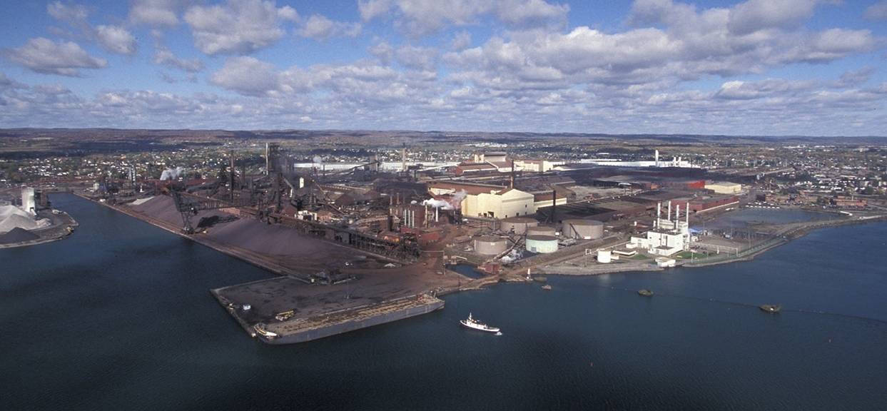
Port of Algoma, image courtesy of the Port of Algoma
So how do the dollar signs boil down?
Taking a look at the 2013 KPMG report, the redevelopment of the port would generate “$262 million in economic activity generated by the infrastructure in the harbour, supporting just under 1,400 person-years of employment.”
Fourteen hundred person years?
Hollingsworth explained. “Fourteen hundred person years employment is the number of jobs created on a 40 hour work week to do the
Dan Hollingsworth, Executive Director of Business Development, SSM EDC
actual work. If you divide that number by 40 it gives you the number of exact positions in the short term to do the actual construction.”
In case you can’t figure in your head and haven’t a calculator handy that formula suggests that 35 positions would be created over the lifetime of the Port of Algoma redevelopment process. It is estimated that the construction process to completion could take 3 -5 years.
The report also indicates that “operations of the public access port are expected to generate $5 million of economic activity under the moderate volume scenario, supporting a total of 17 direct, indirect and induced employment positions” and that employment stimulated by economic impacts would actually generate 1,800 employment positions.
For those who aren’t economists the information can be confusing. Hollingsworth sheds a bit of light.
“Based on KPMG’s 2013 analysis 1,800 jobs would be the increase in production capacity at Essar based on the projection of their planned growth to increase their shipping tonnage per year from 5 million to 8 million. If you look at Essar as the creator of employment we would say that for every 1 job created at Essar 3 more jobs are created in the community.”
Should the redevelopment of the Port of Algoma proceed “the capacity expansion could result in as much as $300 million in incremental revenue for Essar Steel Algoma, which would in turn add as much as $228 million to Canada’s gross domestic product annually.”
*****
Proponents of the Port of Algoma project are aiming to present final reports to City Council by October 2015 although the complex project may require a short extension.
“The work started in earnest in March of this year. We have not produced any reports or analysis yet. We’re just starting to get through some very preliminary information about the opportunities and the traffic analysis,” commented Hollingsworth. “The consultation process is underway and we are looking at how extensive that needs to be. We’re speaking with communities geographically located around Sault Ste. Marie. We’re talking to the tribes in Sault Michigan and there is a connection to both Batchewana and Garden River First Nation. We’re also speaking with the Métis Nation of Ontario.”
A recent hire with the Port of Algoma project will focus efforts on increasing communication and transparency through the use of social media platforms and the creation of their website.
“This Port project has been in the media for 25 years and it is a critical component in how we can develop new industrial opportunities,” shared Hollingsworth. “I just look to my kids and the future of Sault Ste. Marie and if we don’t do this we’re not going to be able to compete globally. Our community is going to continue to shrink if we don’t take advantage of opportunities like this. We have to make sure that the mill is competitive and productive. It’s a huge economic generator in this community and region. It’s a game changer.”
(feature image courtesy of Port of Algoma)
![]()
http://www.scribd.com/doc/275955001/Annex-5-Regional-Harbour-Expansion-Market-and-Business-Analysis-Final